Posts Tagged ‘Canal Walk’

“George Washington’s Vision” at Canal Walk

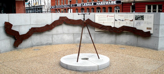
"George Washington's Vision" at the Canal Walk Turning Basin in downtown Richmond, Virginia.WHAT: “George Washington’s Vision” at the Canal Walk Turning Basin in downtown Richmond, Virginia.

LOCATION: West of the intersection of 14th and Dock streets.

Richmond was the eastern terminus of the Kanawha CanalARTIST: Applebaum Associates Inc.

DEDICATION: 2001

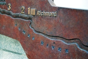
DESCRIPTION: The granite and bronze display is arranged in a circle and centered with a surveyor’s compass. The text and map within the display highlight the key points of the Kanawha Canal and Washington’s vision of connecting the Atlantic Ocean to the Mississippi River.

* * *

"George Washington's Vision" at the Canal Walk Turning BasinFrom the display:

George Washington promoted the concept of a great central waterway long before he became this nation’s first President. A surveyor of western lands as a young man, and later a landowner of vast tracts beyond the Alleghenies, Washington had close knowledge of the western territories, which he feared would be controlled by France and Spain if trade routes to eastern markets were not established.

Washington’s vision was to connect the Atlantic Ocean to the Mississippi River with navigable rivers, canals, and a land portage through what is now West Virginia. After the Revolution, the James River Company was created, primarily as a result of his sponsorship and lobbying efforts. Before Washington’s death in 1799, a large portion of his dream had been realized.

Two canals bypassed the falls of the James River at Richmond, and 220 miles of river improvements extended westward. In the early 19th century, other farsighted Virginians took over Washington’s leadership role. The final elements of his plan were completed in the 1820s, when the Kanawha Turnpike joined the headwaters of the James River to the Kanawha River. In 1835, the James River and Kanawha Company was formed, and within 15 years a canal system stretched to Buchanan, Virginia, a distance of 197 miles.

Canal Walk getting more attention, best to be patient

Chuck "Cotton" Renfro, a canal cruise tour guide for Venture RichmondI’ve been on a handful of cruises on Richmond’s Canal Walk downtown, but only one with a $10,000 camera on my shoulder. They are always entertaining, but I think I finally found my favorite guide.

Reporter Danielle Wilson did a fun 12 About Town story for NBC12.com on the canal cruises that are offered throughout most of the year. The guide for our tour Chuck Renfro, or “Cotton” as he’s better known. He has been a guide with Richmond canal cruises since they began 11 years ago. 

Cotton is best guide I’ve had yet. He was entertaining and full of fun history facts and he even dressed for the part. Other guides I’ve had were knowledgable and full of facts too, but Cotton was hitting his history with exact dates, quizzes for the passengers and his presentation was full of energy.

We were there on a Saturday night from 4:30 to 7 p.m. and the tours were packed on every run. The one thing I noted was that most everyone showed up just for cruise and left. Some people milled around on the canal before or after the tour, which brings me back to my wish there be something to do or a vendor of some type to take advantage of the crowds.

In late August, I met with Lucy Meade of Venture Richmond at a dinner at Morton’s hosted by Richmond.com to discuss the James River. We got off-topic at one point, talking about the Canal Walk, which is under Venture Richmond’s control.

Meade mentioned that the first comparison most people want to make for Richmond’s Canal Walk is the River Walk in San Antonio, Texas. Her point was that for anyone that wants Canal Walk to be a thriving, bustling retail and restaurant hub in Richmond like River Walk is for San Antonio, it should be noted that it took nearly 40 years for River Walk to develop and gain acceptance as a tourist attraction.  She said that organizers in San Antonio tell her it was more like 80 years in the making.

The work to create the Canal Walk in Richmond was completed in 1999 and many people are becoming impatient with the process of developing a consistent entertainment draw. I wrote about this in early August after a rezoning decision was made for the Reynolds Plant that bisects Canal Walk and have continued to follow developments.

Alix Bryan covered an event for Richmond.com about a collaborative session attended by about 40 people on the future of the Historic Canal Walk, hosted by Sixth District Councilwoman Ellen Robertson at the Hat Factory on Aug. 28:

The Canal Walk and surrounding areas are jewels that many cities lack. The riverfront undoubtedly holds the potential to host great community spaces for residents, outdoorsy types, buskers, vendors, singles, couples, families, cosmopolitans, professionals, students, and tourists alike.

A majority present were City of Richmond affiliates, developers, or business owners. Who else gets up early on a Saturday morning for a three hour public meeting? However, the most vocal participants were Bottom residents, or interested citizens–an estimated 12 total. A developer of the soon-to-be 225 apartments at the former Reynolds site, long the obstacle impeding cohesion along the Canal Walk, was in attendance taking notes.

I will have to side with Venture Richmond’s Meade and just practice patience. Richmonders don’t like to be pushed into anything new, even if the “new” thing is something that was old, like the canal.

Will the Canal Walk ever become a tourist hub?

Canal Walk and the Turning Basin in downtown Richmond, Va.It has been more than 10 years since the completion of the Canal Walk and while beautifully landscaped walkways may have replaced the abandoned wasteland that frequently hosted bonfires set by Richmond ’s homeless, the promise of the area remains unfulfilled.

The Canal Walk is a 1.25-mile greenway that connects Tredegar Ironworks to 17th Street in Shockoe Bottom. It features a series of markers and signs that interpret Richmond ’s history and provides a link to many of downtown’s best attractions. And while there has been some commercial development, it hasn’t developed into a tourist hub.

Last week, Richmond City Council unanimously approved a special-use permit to relieve some zoning requirements for a development proposed for the 6-acre Reynolds Packaging Group’s North Plant property along the Canal Walk at 12th and East Byrd streets.

WVS Cos. and Fountainhead Development LLC plan to build more than 225 apartments in a mixed-use development that should remove the Canal Walk’s biggest roadblock.

For more on the status of the Canal Walk, see Richmond.com

Fountain at Kanawha Plaza is double-edged sword

Cascading fountain at Kanawha Plaza in downtown RichmondKanawha Plaza is at  Byrd and 9th streets, just north of the Federal Reserve Building. The park is surrounded by downtown Richmond’s most influential and important employers: The Fed, Dominion Virginia, banks, law offices, stock brokers — you name it.

The park sits above the Downtown Expressway and covers an entire city block. It has a concert stage and grassy lawn that is primarily used for Fridays at Sunset jazz and R&B concerts and occasional festivals.

The stage also provides shelter for many homeless that need a break from the sun during the day. Many homeless sleep on benches in Kanawha Plaza as well.

Image of fountain at Kanawha Plaza in downtown RichmondThe best feature of the park is the cascading fountain, which at the right time of day can look quite impressive among the tall buildings and busy streets.

Unfortunately, I’ve also witnessed the waters of the fountain double as a laundromat for the park’s homeless, and I can only assume that the next step would be bathtime. Not an attractive thought.

Don’t get me wrong. Homeless people getting “cleaned up” is an improvement. I’m sure it’s common in most big cities. Probably encouraged in Europe. I’ve seen plenty of examples along the James of what I assume are homeless bathing in the river.

I’m just not sure I want to happen by the park with out-of-towners enamored with a lovely fountain, only to witness laundry day.

The area is near the Canal Walk and near the former location of the Great Basin (from park signage):

Finished in 1800, the Great Basin was the eastern terminus of the Canal. It was a block wide and three blocks long and was located between Cary and Canal, and 8th and 12th Streets. The Basin was up to 50 feet deep and was probably made by damming a stream valley at its east end (12th Street). Warehouses and trading firms surrounded the Basin and the docks along its stone walls were active. In addition to allowing the long, narrow canalboats to turn around for the trip back up the Canal, the Basin supplied water to various mills around its edge. Railroad yards covered half the Basin in the 1880’s. By the 1920s the Basin had been completely covered over. Construction excavation on the site for the James center in 1983-86 yielded the hulls of batteaux, canalboats, and other artifacts of the canal era, some of which have been saved.

Kanawha Plaza is at  Byrd and 9th streets, just north of the Federal Reserve Building.

NOTE: I chose not to publish my photos of the homeless. I’m not trying to get anyone arrested or start trouble. Just a little disappointed in humanity.

Open the canal to paddlers in downtown Richmond

Let's paddle the canal from the Cross monument to Brown's Island!I want to paddle the canal in downtown Richmond. I love that area and want more!

I’ve written about my desire to form a circuit for paddlers between the James River and the Lower Canal from Tredegar to Pumphouse Park. That one might be a tough sell to CSX and would require a lot more work for the paddlers.

But a more realistic circuit would be an easy one to create that would require relatively little money and maintenance and would provide a benefit to the city. Let’s open up the Kanawha Canal from Captain Christopher Newport’s ‘Cross’ monument at 12th and Byrd Streets to Brown’s Island. 

Paddlers could get out of the canal at Brown's Island.The circuit would allow paddlers access to the river from the Tredegar Beach and the Manchester Dam through Pipeline — which has class III-IV rapids. The paddle up the canal would only be about a half-mile long and would allow more people to be a visible part of the downtown scene.

Why have all these expensive and cool toys like the Canal Walk and the canal if we can’t use them? More time in the water is greater than more time carrying your equipment and paddlers would get behind this kind of opportunity.

Some dedicated paddlers already carry their kayaks back up the catwalk over Pipeline, up the sandy trail to Brown’s Island and over to Tredegar Beach to make the run again. At the end, getting out below the Pipeline overlook and making a short walk up the hill to the canal before paddling to west end of Brown’s Island would be a huge draw to the area.

Hey, if we could get a contraption similar to a ski lift to run under the famed CSX railroad viaduct, that might be a distant second-place option. Sound like fun?

I’ve seen many white-water kayakers carry their equipment from the takeout at the south end of the 14th Street (Mayo) Bridge and carry it the half-mile along the Floodwall Walk to the Manchester Bridge where they could drop in and run the Southside rapids over and over. If they are that dedicated to making the run, what would they do if you let them paddle up the canal instead?

Riverside on the James is right on the Canal Walk, above the Kanawha Canal.There is a reason to expect this circuit is possible.  This is an excerpt from the Downtown Master Plan [See the full .PDF document]:

Over time, the James River’s role as the heart of Richmond’s industry and commerce has evolved. Today it is known instead for its unique recreational opportunities, such as rock-climbing and nationally recognized kayaking. Allow residents and visitors to fully enjoy this unique natural feature by creating a series of clear connections to the riverfront. Although the James River is the geographic center of Downtown, it is difficult for residents and visitors to directly reach the waterfront. One obstacle to accessibility is the layering of infrastructure that lines the riverfront, including the canals that George Washington surveyed, the railroad lines built on top of the canal tow-paths, and the recently constructed floodwall.

Not convinced? Try this:

Richmond’s reputation for world-class kayaking and rock-climbing should continue to be promoted, and improved facilities for these sports should be provided.

Construct a dock at the low-lying iron fence behind the Cross monument.As for the access to the canal, there is a low-lying iron fence (see photo at right) behind the Cross monument and a small dock could be constructed there. There is already a dock at the opposite end of the canal on Brown’s Island and paddlers would be free to make the short walk over to the boat access at Tredegar Beach from there.

I recently visited the beautiful new pavilion at Byrd Park and seeing all the happy paddle boaters opens up another possibility. Let’s make that same opportunity available on the Canal Walk from Brown’s Island down to the ‘Cross’ monument and use that same dock as a launch point.  During one of the many summer festivals at Tredegar, Brown’s Island and the Canal Walk just imagine the “cool factor” the city would get seeing people using the canal.

Paddlers already use the parking area for Belle Isle and the 14th Street takeout when coming off the river downtown, so this area gets plenty of use. But envision the extra draw here. With a circuit, these folks could be a part of the show during many events. To be able to enjoy a big event downtown while also getting to be on the river and having fun by making runs down Pipeline over and over…

Parking area for old Reynolds Metals property, behind the protection of the Floodwall.What about parking? Well, let’s play with the old Reynolds Metals property for a moment. That property will be open for development at some point soon. It has a large parking area that most certainly will not be available to the public if there is another Vistas on the James or Riverside on the James condominium is built.

The Pipeline Rapids Walkway already has a small parking lot with about 10 parking spots available, but that lot would fill quickly.

Paddling the canal would be a fun time.But if a forward thinker was to embrace the river and allow an outdoor shop like Riverside Outfitters or someone similar to run a business out of that area?

Come on Venture Richmond, let’s make it happen. Let’s paddle the canal and give the Canal Walk another draw it desperately needs.