Posts Tagged ‘James River’

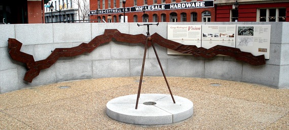
“George Washington’s Vision” at Canal Walk

"George Washington's Vision" at the Canal Walk Turning Basin in downtown Richmond, Virginia.WHAT: “George Washington’s Vision” at the Canal Walk Turning Basin in downtown Richmond, Virginia.

LOCATION: West of the intersection of 14th and Dock streets.
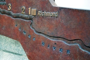
Richmond was the eastern terminus of the Kanawha CanalARTIST: Applebaum Associates Inc.

DEDICATION: 2001

DESCRIPTION: The granite and bronze display is arranged in a circle and centered with a surveyor’s compass. The text and map within the display highlight the key points of the Kanawha Canal and Washington’s vision of connecting the Atlantic Ocean to the Mississippi River.

* * *

"George Washington's Vision" at the Canal Walk Turning BasinFrom the display:

George Washington promoted the concept of a great central waterway long before he became this nation’s first President. A surveyor of western lands as a young man, and later a landowner of vast tracts beyond the Alleghenies, Washington had close knowledge of the western territories, which he feared would be controlled by France and Spain if trade routes to eastern markets were not established.

Washington’s vision was to connect the Atlantic Ocean to the Mississippi River with navigable rivers, canals, and a land portage through what is now West Virginia. After the Revolution, the James River Company was created, primarily as a result of his sponsorship and lobbying efforts. Before Washington’s death in 1799, a large portion of his dream had been realized.

Two canals bypassed the falls of the James River at Richmond, and 220 miles of river improvements extended westward. In the early 19th century, other farsighted Virginians took over Washington’s leadership role. The final elements of his plan were completed in the 1820s, when the Kanawha Turnpike joined the headwaters of the James River to the Kanawha River. In 1835, the James River and Kanawha Company was formed, and within 15 years a canal system stretched to Buchanan, Virginia, a distance of 197 miles.

Deepwater Sponger at Rocketts Landing asks for more fresh water

“Deepwater Sponger” at Rocketts Landing There is a new sculpture in Richmond at Rocketts Landing. “Deepwater Sponger” was lowered into place Thursday. 

“Deepwater Sponger” was lowered into place Thursday, Nov. 19The cast iron figure is a short and stout sort, toting two weights and rests on a bed of concrete that is in the shape of machinery cogs. Definitely worth checking out on your way to diner or drinks at the restaurant next door, The Boathouse at Rocketts Landing.

The statue is part of a series calling attention to the global threat to the world’s fresh water. It is scheduled to be in Richmond for at least two years.

The “Deepwater Sponger” statue next to The Boathouse at Rocketts Landing WHAT:  “Deepwater Sponger” at Rocketts Landing on at 5000 Old Osborne Turnpike. 

ARTIST: Charlie Ponticello.

DEDICATION:  November 18, 2010.

DESCRIPTION: A six-foot, 2,000-pound cast iron sculpture that was previously located at Baltimore’s Inner Harbor and on the campus of Johns Hopkins University. The sculpture is one in a series of five “spongers” designed to call attention to the global threat to the world’s fresh water. It sits on a bluff overlooking the James River between the Sky Line condominium building and The Boathouse at Rocketts Landing. 

Snorkeling the shallow waters at Texas Beach

What can you find under the water?Richmond’s North Bank Park is one of the best places to visit the James in late summer. The shallow waters and calm sands of Texas Beach are a great setting for an afternoon of exploring.

For one, Texas Beach is never as crowded as Pony Pasture, Belle Isle or even the Main Section, which is located across the river on the south bank. Two, the people there generally are more laid back. We observed some college-aged kids kicking back playing guitars, people with dogs and a couple of groups that brought their own folding chairs and beach towels.

When the river levels are low (it was at 3.3 feet that day), a new world of opportunities opens. With no recent rains, the water is clear and the bottom is easy to see. The shallow pools and slower rapids make it safer, including for little children. We brought our masks to see what was going on under the water.

Read more in Snorkeling at Texas Beach at Richmond.com

Taking the path less traveled on the James River

James River Railway Bridge, viewed from below Grant's DamI’ve taken many trips down the James River from Pony Pasture to Reedy Creek, but I almost always follow the normal paths that generally track the southern banks of the river. When the river levels are low, that is sometimes the only floatable path.

Since the water levels in the James are a little higher than normal for late August, I decided to stick to the north bank of the river once I reached the James River Railway Bridge (AKA the Atlantic Coast Line Railway Bridge or Belt Line Bridge). I needed to explore a little and see the river and the scenery from a different angle.

Some of the rapids in this area may be the results of quarried or blasted rockI’m often a guide for friends and family that have never been on the river, and I try to keep it easy, predictable and safe.  I also find that I seek consistency and predictability in my life and sometimes it is good to break away from the routine. 

But when I kayak alone, I usually get a rush from trying the unknown of a new course, even if it isn’t a tremendous challenge. So with reluctance, I skipped Choo Choo Rapids, Cooper’s Rifle and Mitchell’s Gut – the prescribed path for most paddlers.  I love that course, but I was pleasantly surprised by the little drops and tight runs between the rocks and trees along the way.

Entrance to Lower Arch blocked by trees and overgrowthInstead of shooting down Choo Choo, I took the channel through what used to be Grant’s Dam past the entrance to the Lower Canal. Someday the overgrown area where it passes under the CSX railway line on the north bank will be cleared all the way to the Pumphouse, giving  paddlers access to the Kanawha Canal through George Washington’s Lower Arch and creating a new river access at the Pumphouse.

I found plenty of scenery and views of the riverscape that were new to me. According to the Falls of the James Atlas by Bill Trout, much of the river in this section had been altered by man to create and maintain Grant’s Dam, which was built to direct water into the Kanawha Canal at the Pumphouse.

I love the area between the Powhite Parkway and Boulevard bridges.  It is so natural, wild and remote, yet right in the middle of the city. You can feel so free there among the honking geese and hunting osprey — only to hear an Amtrak train streaking its way across the arched railway bridge or a freight train roaring through the trees on either bank of the river.

Crude log table on a sandy island west of the Boulevard BridgeAs I passed under the Boulevard Bridge along the north bank, it again occurred to me how isolated that section of river is, despite the thousands of cars that pass over that area every day by the bridge.

Even though the area south of the CSX tracks is part of the North Bank Park, one would have to hike a long way to reach that area legally, due to the fences that block access along the tracks and the only allowed access is by the walkway tower at least a half mile down river.

Creating an access at Pumphouse would form a needed second access and a loop to the trail.  Plans for bike trails in the area are already in the works.

Trash collected from the James RiverAt the end of the trip I’d collected more trash than normal — likely due to the fact that I’d taken the path less traveled by most everyone.  It was that much more satisfying snagging a few odd bits of river trash, like an inner tube and a broken piece of a styrofoam pot. Sadly, I also found an empty woman’s purse — a sign that not everyone on the river has the best intentions.

Dragon boat racing comes to Rocketts Landing

Dragon Boat Festival in Richmond, Va. Richmonders just acquired one more great reason to love living in the River City: Dragon boat racing at Rocketts Landing.

View from Rocketts Landing of the Dragon Boat Festival in Richmond, Va. The heat was a factor as shade was hard to come by Saturday, but the Richmond Sports Backers teamed up with several sponsors to bring the first Dragon Boat Festival to the James River.  It was a charity event for the Virginia Breast Cancer Foundation.

It was fun, active and brought many Richmonders out to a part of town that probably most had never seen. The crews mostly consisted of corporate teams from around Richmond, but there were also “ringer” teams from cities like Baltimore, Washington, D.C., and Charlotte. Great for Rocketts Landing and the Shockoe Bottom area to have so many people having a great time.

What is Dragon Boat Racing? From the Great White North Dragon Boat Racing website:

Twenty paddlers move in unison, combining strength with teamwork in a boat whose elaborate design originates in ancient China… Dragon boats are 40-foot human-powered canoes decorated with ornate Chinese dragon heads. Led by the rhythmic beat of a drum, teams consisting of 20 synchronized paddlers, one drummer, and one steersperson race the canoes 500m down the river.

Dragon Boat Festival at Rocketts Landing in Richmond, Va. Teams were guaranteed three races and had plenty of time to relax and socialize in between heats. Several teams held organized cheers and calisthenics — obvious attempts to intimidate any challengers. I didn’t participate, but had many friends on a few teams. If it comes back next year, I will certainly find a team to join and do my best.

Dragon Boat Festival at Rocketts Landing in Richmond, Va. My kids enjoyed watching some of the dance teams, tai chi and karate exhibitions and explored the surroundings a little.

We finally got to take in the view of the James River and the Richmond skyline from deck at the Boat House at the top of the Rocketts Landing development.

Dragon Boat Festival at Rocketts Landing in Richmond, Va.