Posts Tagged ‘nature’

Snorkeling the shallow waters at Texas Beach

What can you find under the water?Richmond’s North Bank Park is one of the best places to visit the James in late summer. The shallow waters and calm sands of Texas Beach are a great setting for an afternoon of exploring.

For one, Texas Beach is never as crowded as Pony Pasture, Belle Isle or even the Main Section, which is located across the river on the south bank. Two, the people there generally are more laid back. We observed some college-aged kids kicking back playing guitars, people with dogs and a couple of groups that brought their own folding chairs and beach towels.

When the river levels are low (it was at 3.3 feet that day), a new world of opportunities opens. With no recent rains, the water is clear and the bottom is easy to see. The shallow pools and slower rapids make it safer, including for little children. We brought our masks to see what was going on under the water.

Read more in Snorkeling at Texas Beach at Richmond.com

Taking the path less traveled on the James River

James River Railway Bridge, viewed from below Grant's DamI’ve taken many trips down the James River from Pony Pasture to Reedy Creek, but I almost always follow the normal paths that generally track the southern banks of the river. When the river levels are low, that is sometimes the only floatable path.

Since the water levels in the James are a little higher than normal for late August, I decided to stick to the north bank of the river once I reached the James River Railway Bridge (AKA the Atlantic Coast Line Railway Bridge or Belt Line Bridge). I needed to explore a little and see the river and the scenery from a different angle.

Some of the rapids in this area may be the results of quarried or blasted rockI’m often a guide for friends and family that have never been on the river, and I try to keep it easy, predictable and safe.  I also find that I seek consistency and predictability in my life and sometimes it is good to break away from the routine. 

But when I kayak alone, I usually get a rush from trying the unknown of a new course, even if it isn’t a tremendous challenge. So with reluctance, I skipped Choo Choo Rapids, Cooper’s Rifle and Mitchell’s Gut – the prescribed path for most paddlers.  I love that course, but I was pleasantly surprised by the little drops and tight runs between the rocks and trees along the way.

Entrance to Lower Arch blocked by trees and overgrowthInstead of shooting down Choo Choo, I took the channel through what used to be Grant’s Dam past the entrance to the Lower Canal. Someday the overgrown area where it passes under the CSX railway line on the north bank will be cleared all the way to the Pumphouse, giving  paddlers access to the Kanawha Canal through George Washington’s Lower Arch and creating a new river access at the Pumphouse.

I found plenty of scenery and views of the riverscape that were new to me. According to the Falls of the James Atlas by Bill Trout, much of the river in this section had been altered by man to create and maintain Grant’s Dam, which was built to direct water into the Kanawha Canal at the Pumphouse.

I love the area between the Powhite Parkway and Boulevard bridges.  It is so natural, wild and remote, yet right in the middle of the city. You can feel so free there among the honking geese and hunting osprey — only to hear an Amtrak train streaking its way across the arched railway bridge or a freight train roaring through the trees on either bank of the river.

Crude log table on a sandy island west of the Boulevard BridgeAs I passed under the Boulevard Bridge along the north bank, it again occurred to me how isolated that section of river is, despite the thousands of cars that pass over that area every day by the bridge.

Even though the area south of the CSX tracks is part of the North Bank Park, one would have to hike a long way to reach that area legally, due to the fences that block access along the tracks and the only allowed access is by the walkway tower at least a half mile down river.

Creating an access at Pumphouse would form a needed second access and a loop to the trail.  Plans for bike trails in the area are already in the works.

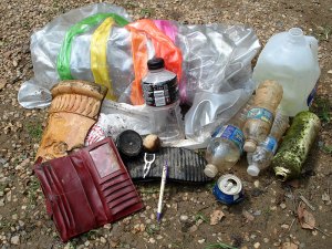
Trash collected from the James RiverAt the end of the trip I’d collected more trash than normal — likely due to the fact that I’d taken the path less traveled by most everyone.  It was that much more satisfying snagging a few odd bits of river trash, like an inner tube and a broken piece of a styrofoam pot. Sadly, I also found an empty woman’s purse — a sign that not everyone on the river has the best intentions.

Taking ownership of Pony Pasture

Crowds at Pony Pasture Rapids Park in Richmond, Va.Pony Pasture Rapids Park is an urban paradise for many. A cheap way to make the best of one’s day for those that can’t afford a trip to the beach or don’t have the time to leave the city for a vacation.

The exposed granite boulders are a big draw for Richmond’s rock hoppers and sunbathers. Family gatherings are as popular as inner tubing, kayaking, swimming, fishing and partying.

But there are many people who take the pristine park conditions for granted. It takes a lot of work to keep human interference from tarnishing Pony Pasture’s natural beauty.  Between the James River Park System’s staff and the many volunteers and dedicated park-goers, the work gets done.

I am one of those proud people and Pony Pasture Rapids Park is now my park. Actually, many people own the park, and taking ownership is encouraged. After all my years of using the park, I’m now volunteering my time to maintain it and defend it from those that abuse it.

Aluminum cans left at Pony Pasture Rapids Park in Richmond, Va.I spent five hours clearing trash and helping people park cars at the west Richmond park on the hottest day of the summer. The official high that day was 105 degrees, beating the record of 99 for July 25. Didn’t matter, the park was packed.

I can claim four garbage bags worth of trash and recycling. I had help, as people who saw me coming with my trash bag would volunteer things they had collected from the river. It was good to have children helping a little, especially with aluminum cans.

Other than all the of senseless disposal of diapers all over the place, the worst part of clearing trash was a six-pack of glass bottles smashed on the rocks.  That malicious act took the longest to clean. I also found an enclave of more than 80 cans, bottles, boxes and food containers that was about as bad as it gets. The worst part was that a trash can was only 15 feet away. Trash in, trash out people.

Cigarette butts left at Pony Pasture Rapids Park in Richmond, Va.I think the cigarette butts were the most disappointing thing I found. Smokers know better and should be prepared to clean up after themselves.  I found 70-plus butts in one spot. The location suggested to me that it was obviously a good spot to see nature more than people-watch and I was disgusted by the lack of respect for the outdoors.

Parking is another issue at Pony Pasture. Between 1 p.m. and 6 p.m. on most summer weekends, the lot gets full and the park system workers and volunteers help manage the flow of cars into the park and keep everyone happy, according to park manager Ralph White.

Lines for the parking lot at Pony Pasture Rapids Park in Richmond, Va.By 3:30 p.m., the line to get into the lot was 20 cars deep and the wait was about 20 minutes. The lot — which is the largest in the park system — has 80 parking spaces but can be expanded with creative management to 110 spaces, White said.

“In the early ‘80s, riff-raff was so bad, people petitioned to have the park closed – twice,” White said. The Pagans and Hell’s Angels motorcycle gangs were a big part of the problem, he said — doing donuts with motorcycles in the gravel, smashing car windows, starting fights, drinking, doing drugs, womanizing, etc.

Pony Pasture was a rowdy and untamed place in those days and citizens weren’t happy, but the park was never permanently closed.

That was a long time ago. The park seems to be more popular now than ever and keeping peace and harmony for a diverse and multiculural crowd on a hot day is beneficial to everyone. 

“It’s a parks issue, not a police issue,” White said. Having the parks department and volunteers run the parking lots at peak hours frees police from having to dedicate several cars to patrolling the park.

White said Richmond police usually dedicates one unit to Pony Pasture on the weekends.

“There is no one breaking into cars or starting fights… and everyone gets along much better,” White said. Having attendants manage the parking lot at peak hours has helped ease tensions and people seem to respect the park more now.

While I was there, the police mostly concerned themselves with the cars in line for the parking lot that blocked westbound Riverside Drive. There were no calls for Emergency Medical Services, no rescues, no arrests that I saw.  Everyone was getting along, despite the close quarters, heat and huge crowds.

There were at least seven volunteers, including a two couples that lived near the park that like to ensure that their neighborhood is well-maintained. Another young man volunteered in the park all day doing whatever the parks department had for him. He is a regular and has taken ownership of his Pony Pasture.

I will continue to volunteer. The afternoon didn’t seem like work.  I was earning time to enjoy my James River. 

If you see something you don’t like about any city park, take action. Take ownership. Make the park yours.

Find out how to help the James River Park System or any of the volunteer groups: Friends of the James River, James River Outdoor Coalition and the City of Richmond’s Department of Parks, Recreation & Community Facilities.

Granite rocks are a big draw to Pony Pasture Rapids Park in Richmond, Va.

An ode to the James River Railway Bridge

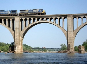
James River Railway Bridge, also known as the Atlantic Coast Line Railway BridgeMy favorite place to stop on a paddle trip down the James River is the area around the James River Railway Bridge.

The bridge, also known as the Atlantic Coast Line Railway Bridge or Belt Line Bridge, is located between the Boulevard Bridge and the Powhite Parkway. The areas east of the bridge on the south shores of the James are part of the Main Section of the James River Parks System. [See a slideshow]

People can see the bridge from many angles, but the best way to view this entire area of the James is from the many huge exposed granite boulders that surround the bridge. The feeling of solitude and serenity is a place surrounded by the sounds of commerce is a unique pleasure.

CSX train crosses the James River Railway BridgeListening to the roar of the river; watching birds soar above; catching glimpses of wildlife and looking for the perfect photo — contrasted by the train horn blasts and hum of diesel engines; the droning of the cars on the Powhite Parkway.

There are unofficial hiking trails from Riverside Drive, but parking is limited. Access to these areas includes crossing railroad tracks and the trails are not maintained for high traffic, so read the signs and proceed with caution. The northern portion of the area is accessed from trails that lead from North Bank Park and the bridge is in view from Pumphouse Park, though not accessible due to fenced-in CSX tracks.

Exploring in this area is a treat. There are many nooks and shallow pools of water to explore when the water is low. I fell in love with this area during a hike in late summer of 2007 when the water level was absurdly low. The rocks looked so unique, smooth and odd — a complete landscape change.

I now drive by this area almost every day on my commute to work on the Powhite or the Boulevard Bridge and longingly steal glances of the beautiful arches and the river.  I’ve had many conversations with readers, friends and fellow James river lovers that feel the same way about the bridge.

Kayakers stop at the Choo Choo Rapids just below the James River Railway BridgeThe remains of Grant’s Dam are nearby, and what’s left of that dam helped create the whitewater run known as Choo Choo Rapids. There is a nice beach right after the rapids and multiple places to stop for a food break or just to relax. These rapids can be run over and over again if you carry your kayak back up the rocks on either side.

The Lower Arch of the Kanawha Canal isn’t much further along the north bank of the James, just below Pumphouse Park. The famed George Washington’s arch is there, though the entrance from the river is blocked.

There are two main islands just east of the James River Railway Bridge that have areas worthy of picnic spots as well. At times you might find a picnic table left on the southernmost island (Cedar Island) though on my last visit, it seemed to have been washed away.

Stone pillars at James River Railway BridgeThere are many 25-foot granite piers left from the previous railway bridge. A couple of them have ropes and ladders to allow for a climb to the top. Use your best judgement if you dare climb, but let me just say…the view is worth it.

HISTORY: The railroad bridge was completed in 1919 for the Richmond, Fredericksburg and Potomac Railroad, and used by the RF&P and the Atlantic Coast Line, which are now part of CSX.

David D. Ryan wrote in The Falls of the James about the term “Falls of the James” and to what it refers:

Majestically arched stone and concrete Seaboard Coast Line Railway Bridge and the remains of the Richmond, Fredericksburg, and Potomac Railroad Bridge. The SCL Bridge was opened for rail traffic in 1919; the RF&P Bridge was constructed in 1891 and razed twenty-eight years later.

Remains of the RF&P bridge are still standing below the arches of the James River bridge. The James River Bridge project was among the earliest major projects to rely on poured concrete, Portland cement. Up to that point, railway bridges were made of heavy timbers, iron or stone. In the early 1900’s, concrete was introduced as a new material for bridge construction.

The purpose of the James River crossing was to provide a straight route through Richmond for passenger & perishables trains running between Florida and the Northeast.

James River Railway Bridge, viewed from Riverside Drive

Finding roses in the middle of the James

Roses in the middle of the James RiverThis past weekend, I went for a long-anticipated paddle up the James River from the 14th Street Bridge into the cluster of rocky islands around and west of Mayo Island. My goal was to explore the many waterfalls, rapids, nooks, cracks and left over man-made debris among these wild islands in search of great photos and scenery.

Roses in the middle of the James RiverI have a story and slideshow coming soon on everything I discovered on my kayak trip, but I wanted to share something neat. At the end of my trip, I checked on something I ignored as I paddled by when I first got on the river at the Floodwall takeout on the south end of the 14th Street Bridge. I had seen some pink spots in the trees in the corner of my vision — unusual in that area.

On my way down river and headed back to the takeout, I checked it out. Seems that some nice hot pink roses had taken up residence on the eastern tip of one of the sandy islands. It wasn’t just a bush, this was a full-blown tree at least six feet tall. They were in full bloom and looked very healthy.

This is a rough and rugged section of the James, at the end of the Falls of the James in downtown Richmond. There is little human visitation to this spot, other than fishing boats or the occasional paddler.

Roses in the middle of the James River

Roses in the middle of the James River